
'Enjoy playing with your toy', said the woman at Cotswold Outdoor shop in Harrogate when I bought a combined GPS and altimeter midway through 2008. The 'toy' afforded me the dubious pleasure of venturing up Marilyns surrounded by forests and checking contentious heights. When I reached 600 I had vowed not to go near small forested hills, but the last few years have seen an increasing number of them being bagged. They give a certain degree of masochistic satisfaction, as well as problem solving when deciding which gap in the forest might lead to the summit, or even elation on finding a path or track to the summit that is unmarked on the map.
During the summer I divided my time between Glen Isla and Strathpeffer during a spell of warm, sunny weather. Thus I climbed Carn a'Choin Deirg before any more fences go up, as well as visiting 692m Beinn Tharsuinn and its twin top. A relatively new wind farm on Sidhean a'Choin Bhain enabled a pleasant round of the head of Strathrory river, although the churned-up track coming off Meall a'Bhreacain was pretty ugly. While in Glen Isla I managed to tidy up the Grahams in region 7 as well as various lower hills, the approach past the Falls of Unich to Hunt Hill being the best of the bunch. The cairn didn't mark the actual summit though, according to my altimeter. The trig point on Hill of Wirren proved to be defended by two electric fences, with a stile inconveniently situated a few hundred metres south of the summit.
During October I visited the Cheviots and surrounding hills for the first time. The summit of The Cheviot proved as uninspiring as anticipated, although the horizontal snow didn't help. Most bizarre hill in that area was Belling Hill during a day of heavy snow showers. Discovering parking space (at NT644114) and a track not marked on the map was a bonus. I passed 'no entry' signs and walked up through an avenue of stacked timber several metres high, but the place seemed deserted so I ventured on. The summit area has been felled of trees but is not far from where the track ends, so it was bagged relatively easily using combined tactics of GPS and carefully picking my way through the forest debris. On returning down the track I was surprised to come across a lorry being loaded with timber. I prepared myself for a telling off, but all I got was a friendly wave from the driver as I hurried on, hood up against the heavy snow. Perhaps walkers bagging the hill are a common occurrence.
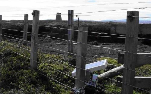
Electric fences on Hill of Wirren (photo: David Hughes)
The best hillwalking days of the year were all on repeat hills - Fuar Tholl, and Sgurr Choinnich and Sgurr a'Chaorachain from a snowy Glen Carron on two fabulous days at Easter, while Buckden Pike (35B) had a fantastic inversion layer on the last day of the year, providing the best views seen from that hill in 30 years of climbing it.
So how useful was my 'toy'? The GPS proved an asset on forested hills, but the altimeter was inconclusive, as expected. The attendant tops of Beinn Tharsuinn and Carn na Coinnich were all measured to be slightly lower, but it was too close to call, and I didn't have the inclination to take repeat readings. Closer to home, Boulsworth Hill has a gritstone outcrop a few metres south-west of the summit, which my altimeter consistently told me was one or two metres higher than the trig point. I'm sure I've read a report concerning this one but I couldn't find anything about it in back issues of Marhofn.
