
Hail Storm Hill had a mention but was not listed when the Hall of Shame was inaugurated in the first edition of Marhofn in 1999. It fully deserves a place there on a number of counts. We approached from the south via a tooth-loosening cobbled road. People were walking but the majority of the vehicles up there seemed to have brought trail bikes with them. The rasp of engines was with us for most of the day. Taking a route east away from a pair of burnt-out cars, we first went up Hunger Hill by a rutted route caused by endless motor-cycle ascents and descents. Heading north on a fine partly-cobbled fell road, we were passed incessantly by more noise-generating bikes. Passing an abandoned and wrecked car, then 20 or so dumped car wheels, we turned off the road to Hail Storm Hill itself. Big boring bog describes it perfectly. We traipsed over endless waterlogged tussocky ground to locate what could reasonably be called the highest point, then turned off south for Knowl Moor. The trail bikers and their noise were everywhere. They seem to use the moorland freely, and some doubtless see it as a duty to churn the peat into a black porridgy morass. On the passage to Knowl Moor - very juicy going at the best of times - there were several places where small elephants could have been lost without trace in the goo generated by bike use, and a section of the final slope was all but scoured free of vegetation by yet more activity. Our next ascent of this hill will be some time off.
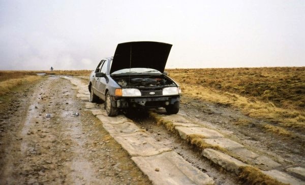
On the way to Hail Storm Hill (photo: Trevor Littlewood)
Peter Collins: I was turned back on 24 April near Loch Pitcarmick by an English-sounding Land Rover driver - usual stuff - no right of way - clients shooting (in April?) - disturbing the birds etc. 'No parking' sticker under my wiper on return to road. He suggested a 'right of way' from Kirkmichael.
Bill Fairmaner: Two high, locked gates and signs saying 'Construction Site - Keep Out'. No it isn't: the masts on top have long since been completed.
Ken Butcher: As I descended the lower slope, and not observing any gateways through the field to the car, I turned towards Monksfoot. From some 200 metres away a young woman came running towards me and wanted to know what I was doing in her back garden (she considered Common Hill her back garden). She saw me to the track and well past her cottage.
I drove from Dundee and turned south at Taynuilt to see deer fences with barbed wire and frequent 'Danger Deer Keep Out' notices. However, as I booted-up at the track end for Ballimore, a friendly shepherd suggested it would be safer to park the car 200 metres down the track, as forestry lorries used the public road. The December day was dreich so I drove to the mast at Gallanachmore. I had passed through three gates when I saw a car enter the property and then a whistle meant for me. Foolishly perhaps I retraced my steps to intimate my intentions, only to be met with 'no way, the access code is not law' etc. I drove to the adjacent croft, called Laggan (sea-diving and accommodation), and explained that his neighbour had refused access to my intended route. I was given instructions to cross the lawn to a gate, cross a field to a power-line pole, then dog-leg up the hill to the dyke (the boundary between the neighbours). It was not long before I deserted the heather and was over the dyke and on my intended track. I returned the same way to the car at Laggan.
Bill Fairmaner: Various 'Keep Out' signs on the track up from the east. Defaced. Obviously, I ignored them.
Jon Metcalf: Amazonian thorn and thicket along the ridge was enlivened by seeing a stoat near the trig point. An already unsatisfying route was then completely ruined by some jumped-up GOML on the way off.
Jon Foote: I had no problem after the Ludlow meeting - parked at SO622379, went up the little footpath to the ridge and along the path to both summits, reasonably well under cover unless you meet a GOML actually on it. It certainly should be a right of way, must have been in use for centuries.
I struggled to the summit from Loch Duntelchaig, through deep heather, long grass, conifers and head-high bracken, which had already damned it in my eyes before I met the stingers. I was nearly down, forcing a route through clinging bracken only 100 metres from the forest track, when I felt several hot needles pierce the back of my hand. I'd brushed against a swarm of bees hidden in the fronds. My yells were probably heard in Inverness. I was 'lucky' in sustaining only four stings. As I am mildly allergic to bee venom, I was unsurprised to watch my hand swell over the next few hours to impressive proportions. It certainly made the drive home next morning more entertaining than usual.
A delightful few hours was spent on a circular visit around Loch Scammadale to claim Cruach na Seilcheig and Carn Duchara prior to parking at the track entry to the quarry. I did not venture that way but spent nearly an hour up and down the road and in and out of the forest, experiencing the same problems in locating and keeping to the two paths as Jon Metcalf reported in Marhofn 84. Eventually I decided to just go for it as straight as I could, up the hillside, fighting brambles, stumbling through rotting branches and scrambling over upturned tree roots until I reached the forest track. Ha - 100 metres to the right a change of tree species, a stream, then higher up a felled area with tracks almost to the summit - 110 minutes of ascent. The return route followed the stream to the road, below the track and keeping further east - 20 minutes. The stream was dry in summer and would be difficult to locate at the road as it is in a small pipe. With Jon's and this report, I propose this hill as the 'shit of the year'.
Having not researched Benbeoch I decided this would be a quick up-and-down in the late afternoon via the dismantled railway track from just east of south. How wrong! I wish I had read the comments on this hill in Marhofn 84, but my Internet search did not pick this up. I think things have now got even worse. My first attempt was along the track, starting at NS513756 on the B741. Easy, break out to the edge of the forest, follow the edge for a wee while and then strike west to the hill. After ignoring the 'No Admittance' signs (standard practice) you come to a scooped-out area with rather large vehicles hurling truck-loads of rocks over the edge. Without a tin hat, I decided to retreat.
The next attempt was to go further east to the forestry track starting at NS523086. Following this north-west from the main road, I took the first left to reach a locked gate. There was a 'No Entry' sign and a tripod on which there looked to be a mounted microphone. This track turns out to be very dangerous, and a stronger warning should be on the gate. I did not check the exact location, but at about NS510086 the track ends with no warning and a vertical drop of about 200ft into the mine. I did not get too close in case the track was undercut. No way here even for the most determined. I walked back to the locked gate and tried north to see if I could get in behind Benbain, but there were no forest breaks to allow a chance of access. Now totally annoyed, I abandoned the attempt, realising that the time spent messing around here could have been more effectively spent on Craiglee to the south.
While debooting at the car, a guy in a four-wheel drive vehicle came out of the forest track and stopped to talk. He told me that the mining operations have been greatly extended in the last year, and when they finish (in about two years time) all the trees will be flattened to make way for a large wind farm. He was just off to Castle Douglas to go to a protest meeting. Before leaving, I decided to go to reception at the mine and ask what was happening. I was told that there was absolutely no access to the Marilyn and that this had been the case for a year, since mining operations now totally encircle the hill. From what I could see going on, there might be one less Marilyn to do, as British Coal appear to be completely destroying it.
Alan Dawson: The sad part is, it's an impressive rocky little hill.
Complete recalibration of my spiritual Marianas Trench. The prototype for Hell's soundtrack drowns out anything natural in this hard-hat disaster area. There was nobody around to ask about safe access past the continuously thundering trucks, or about when it might be least hazardous, or disruptive to the licensed vandals, to venture into the explosion hazard zone. Utterly demoralising, surpassing even the gauche ruin of Dundry Down as an all-time low spot in my hill experience. It is the only prominence for miles around, so let's blow it away for road aggregate. Come on planners - where are the checks and balances - where is the defence of the public interest - where is the defence of the uncorrectable, the unrecoverable? What have we come to? It must have been beautiful once. Now it's like The Shire under Saruman. Peter Jackson could have used the sorry remnants of this former haven to provide location shots for the fictional brutalisation of defenceless beauty in The Return of the King. All responsible should hang their heads.
Ken Whyte: My most vivid memories are of two things: coming across an abandoned JCB digger while approaching the summit of Conachair from the direction of the highest radar paraphernalia, and that monstrosity of a power house which is so carefully edited from official photographs. Talk about double standards!
Barbara Jones: David and I had a quick and relatively smooth crossing to St Kilda in 2002. We got a grilling from the guy in charge and weren't sure if we would be allowed to land. We had an evening ashore round the military bit, a morning doing the round of Conachair, then sailed round the smaller islands and stacks before anchoring again in Village Bay and heading back to North Uist before the weather broke. Looking back it's the military installations that come to mind first, and I have to work quite hard to conjure up the native St Kildan remains and the natural surroundings, though I enjoyed seeing the sheep and the cleits (those little store houses) dotted all over. I find that really 'special' places that have been hyped up often disappoint. We had sailed there from the Monach Islands, which were low and sandy, with wonderful colours in the surrounding shallow waters. They felt really special and away from it all, with just a few ruined stone houses that once formed a village. One dilapidated house that was used by local fishermen as a bothy had wonderful pencil drawings on the walls, of white-horse breakers turning into real horses. There were old and new lighthouses, ordinary sheep, rabbits, buzzards, ravens, a tern colony etc. The sun was shining and we had the three islands to ourselves.
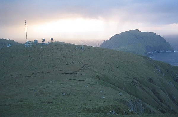
Clutter on Conachair, with Soay beyond (photo: Ann Bowker)
