
Over the years many comments in Marhofn have been on the general theme of 'is point A higher or lower than point B?' In last year's issue there were such remarks about several hills, including Cacra Hill (28B) and Lambrigg Fell (34D). In what follows I assume that A and B are of similar height.
There is one method which can sometimes be used with great accuracy. If you are lucky enough to have a sea horizon, and if, from point A, point B appears exactly on that horizon, then B is lower than A by an amount which depends only on the height of A and the distance of B. Here is a little table which gives the number of metres by which B is lower than A for some specimen heights and distances (interpolation will be sufficiently accurate for other values). Average atmospheric refraction has been allowed for. When making the observation, especially over short distances, you need to squat down and line up the highest point of A, not just stand on the summit.
| Distance of B | |||
| Height of A | 1km | 3km | 5km |
| 100m | 5m | 15m | 24m |
| 200m | 7m | 21m | 35m |
| 300m | 9m | 26m | 43m |
| 400m | 10m | 30m | 50m |
| 500m | 11m | 34m | 56m |
| 600m | 12m | 37m | 61m |
| 800m | 14m | 43m | 71m |
| 1000m | 16m | 48m | 79m |
| 1200m | 18m | 52m | 87m |
I suspect that these values are larger than many walkers would expect: indeed this may give a scientific basis for the old rule that 'the other peak always looks higher'.
Now you don't usually find that the top of B just lines up with the horizon. But if it is not much above, then you can estimate by how many metres B exceeds the value derived from the table. Estimation is made easier if there is a trig point or a human figure on B, so take a companion with you. Nor do you always get a sea horizon. But often in one direction (either A to B or B to A) there is a distant horizon at a much lower level than the two hills. In this case you can reduce the height of A by the approximate height of that distant land before finding a value from the table. It is not as accurate as with a sea horizon, but still quite reliable.
Obviously there are many cases where this approach will not work at all. But when it does it can be surprisingly accurate. A classic instance was Illgill Head (34B) where, from the highest spot on the east top (which is not actually at the stone shelter), the west top appeared just below the sea horizon, thus proving that it is 5m lower. In this instance, that fact was not in doubt, but it did confirm that the main summit does not reach 610m.
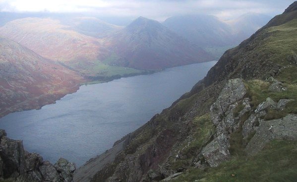
Wastwater from Illgill Head (photo: Ann Bowker)
In making estimates of relative height there is another point worth bearing in mind. If when looking from A to B there are higher hills behind, then B may appear lower than its true value, whereas if there is low ground (or sea) behind then B will appear higher. I have never been on Cacra Hill and so cannot comment with authority, but I just wonder whether this accounts, at least in part, for the impression that Eddie Dealtry reported. Looking east, the distant ground is much lower than it is looking west. (As for 'round dome versus sharp peak', this is not a factor that I have found relevant.)
Jim Bloomer reported on Lambrigg Fell in Marhofn 93. As it happened I was there just before receiving the last Marhofn, and was entertained by the untidy notices asking walkers to stick to the marked 'bridal way'. But my own notes confirm that I reached exactly the opposite conclusion to Jim. I wrote at the time 'the east top is certainly higher than the north top, probably by 2m or so'. (I think all are agreed that the south top is the lowest.) As a matter of interest, from the new summit the small wind farm so well seen from the M6 is in clear view, though it is not seen from point 338m - not that that proves anything. I think these conflicting observations confirm the wisdom of the policy of leaving things as they are until definitive evidence for a change is produced.
One last hill to comment on: Mynydd y Cwm (30C). The techniques described above are of no help here, but I can add (a) that you cannot rely on contours to estimate a summit height to 0.5m, as the contours themselves (and indeed any spot height not at a trig point or bench mark) could be out by up to 2m or 3m, and (b) Explorer 265 clearly shows that in traversing the col you can always stay above the 155m contour. Now there could just as easily be errors of 2m to 3m here as at the summit, so the status of Mynydd y Cwm remains uncertain. All I am suggesting is that the OS mapping does not itself support a case for the promotion of Mynydd y Cwm to a Marilyn.
