
Richard Webb: Not knowing about its status (149m drop), so not looking for trouble, I visited both the highpoints marked on the orienteering map before a descent to the control. There was definitely a little downhill to the cairn on the knoll which corresponds with the 337m summit height on the Explorer map. There are three knolls that are candidates for the summit. I think the eastern one is the highest, the western one is the OS top and the middle one is much lower than the eastern one. The hill needs a careful visit to be sure. I am not making a claim, but flagging up the possibility of promotion; I was running, not surveying. Although I did not visit the OS-marked cairn, I am happy to claim the summit, satisfied that I visited the highest point (the eastern knoll).
Jon Metcalf: The top sports cairns on both sides of the border, neither visible from the other. A hag between them seems higher than both (by GPS), but is firmly in England.
Chris Crocker: The obelisk war memorial at the top of Cracoe Fell (SD993588) is probably at least as high as the official summit, and possibly higher, as the ground rises quite steeply from the 500m contour. I spent five hours doing a circuit of the fell and found little of interest other than the obelisk; not worth the time spent. The summit is in featureless heather and has no paths to it, testimony to its lack of visitors. Nearby Sharp Haw was a better hill.
Chris Bienkowski: It is definite that neither trig point is the top. Near to the 561m trig is an elevated peat hag, with a pile of stones on top, which is about 2m higher than the base of the trig. According to my GPS the trig is at 59255 58728 and the peat top at 59194 58738. There is another cairned top on a rock outcrop the other side of the trig, but this looked lower. I'd guess that the rock outcrop by the 560m trig point is just about the same height as the peat top.
Alan Dawson: A conference at Lancaster University encouraged me to make a return visit, armed with my new altimeter. So I sat in the car park (in a car) for an hour as the visibility varied from dismal to minimal, then gave up and headed back north (I just managed Larriston Fell in the fading light, which was unpleasantly spongy once off the forest track). I hope to visit Ward's Stone again this year and try to reach a firm conclusion.
John Morris: The official 267m top, with large stone and plaque marking 'The Chiltern Summit' is at SP891091, north of the car park and north of the 267m spot height shown on the 1:25000 map. There is a cafe serving bacon rolls, tea and cakes.
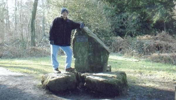
The official highpoint of the Chiltern Hills
Alan Dawson: The summit is 569m at NT000099, 200 metres north of the 567m spot height on LR78. Apologies to Gordon Ingall, Lindsay and Janet Munro for not mentioning this before.
