
More suggestions for those hills that are enjoyable in retrospect...
Charles Knowles: In June I was told in no uncertain terms to keep off the Hydro road leading up to Maovally, by a nasty character who claimed to be both a Hydro employee and keeper of three estates. I reported this to both the tourist information office and ranger service in Lairg, who were aware of his reputation.
Richard Webb: There is a particularly active Yorkshire GOML on the western approaches to this hill (near Moniaive). The nearby MBA bothy has been trashed (and closed due to vandalism and anti-social behaviour) and it is proving difficult to get access for maintenance via the road past the former farmhouse at Cornharrow. The inhabitants at Cornharrow have suffered years of abuse at the hands of drugged-up partygoers at Manquill and have turned GOML. The road to the house is okay but the house should be avoided. This approach is now hopeless anyway due to trees, which are at that annoying stage where there seems to be no way through. If the GOML doesn't get you the trees will.
Trevor Littlewood: Three separate outfits are less than keen to see you on this hill. As maps indicate, there's the large MOD Warcop range which includes Mickle Fell (as an overshoot area). English Nature has a reserve which takes in the area, and there's Strathmore Estate which owns the hill and much of the rest of upper south Teesdale. Monday is a fair time to go as it's generally a 'no-shoot' day which allows access by the western approaches on public rights of way. Also I've found that there's been a moratorium on shooting, for sheep management purposes, around the first two weeks in July. We've used that period several times to go in and do Little Fell and other minor 2000ft tops, as well as Mickle Fell. On Little Fell you come across serious-sized ordnance lying on the ground, though I've never seen anything on Mickle Fell itself. The wonderful empty and open crest of the hill between the large summit cairn and the trig has a green vehicle track line running over it. On the whole I think it's smooth enough for the average family saloon to motor; it's probably down to army landrover activity. There could be tighter access restrictions to come in the area as the MOD is seeking further to restrict public access and historic grazing rights; a campaign has been going on against the move.
Jim Tinnion: There's now a guard house (a portakabin actually) just at the start of the track from the layby to the top. Running up past it is simply not an option. I was politely but firmly refused access and referred to the guard house at Sennybridge.
Gary Honey: Decided it was time to have another go at this one (Feb 2002). The cloud was lowering, the light failing and it was Sunday evening; excellent conditions to leave the road. Also the portakabin has disappeared and the track has acquired a new surface. The red flag was flying by the B4519 but none of the other flags, so putting this down to a forgetful squaddy I took the plunge. When leaving the track for the last few metres a tinny klaxon started to beep, sending the heart racing enough for me to not take the usual summit photo of Wallace (cuddly toy). Uncannily it stopped when back on the track. Not sure if this was some sophisticated intruder alarm or just unlucky timing.
David Rawden: I did a recce on Housedon Hill but couldn't decide on how and where to tackle it. The most promising (I thought initially) turned out to have a public footpath sign pointing to a gate which had notices reading 'Beware of the Bull' and 'Keep Out, No Admittance'. I thought it wise to abandon it for the moment, but wonder if anyone else has suggested the best way to tackle it.
David Robinson: In August I called at the tourist information office in Wooler to check on any FMD restrictions. They recommended that I approach by driving via Lanton to Crookhouse, which I did but no one was present to give clearance to park. I took the bridleway north and then followed the wood edge to summit. The high point is not in the wood, but about 200m south.
Chris Crocker: This is the most unpleasant hill I've ever climbed. As I had two OAPs with me, I started up the track to the BT mast, but before we'd gone 50 yards we were turned back by a pompous female who was evidently the resident of the first house. 'There's no access to this hill at all, it's entirely private land' she said, adding 'we get a lot of people wanting to come up here'. So I followed the Bowkers' route, a purgatorial ascent through thigh-deep gorse, heather and brambles (I failed to find the faint path mentioned by Charles Knowles in Marhofn 58, probably because I started further west from Polgear). On my return along the ROW which contours the bottom of the hill through farmland, I was accosted by another resident who asked what I was doing here (he had evidently not witnessed my sortie up the hill). 'Just following the right of way to the road' I replied. 'No rights of way here'. 'Yes there is, from Menherion, it's shown on my map, which is brand new.' None of the paths around Carnmenellis have any waymarks or signing, though I did see a pole at Polgear farm which looked like the top had been removed.
Paul Richardson: We approached in deep murk via the forest road from the NW. That gap in the trees looks much less bald on the ground; a firebreak a little further on is far more convincing. We went up and met a wall of spruce. Having climbed this far, we decided (as you do) that a short, sharp push would see us clear of the trees and onto the open hill. We crept, crawled, ducked and dived through Santa's grotto of soaking wet sitka and found (as you do) that this notion had more to do with desperation than optimism. Flagellation with wet evergreens. Like being embraced by a giant hedgehog. And disoriented, too. I began to feel that if we were ever seen again, it would be as fragments of bleached bone among somebody's Ikea shelving.
Somehow we managed to stagger out, looking like spruce-needle flavour candy floss. Following the forest road around the hill, we found an easy way up through young trees on the east side. There was enough visibility to suggest that the top would be a good viewpoint in better conditions. We went back through the gap. It is easy, if less straightforward than the map makes it look, its accessibility concealed by encroaching trees and a short, steep slope. Isn't it good, Norwegian wood?
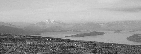
Loch Lomond from Bromley Muir, near Ben Bowie
Jimmy White: Dreich day, trees dripping, trees, trees and more trees. Every forest break ended in a dead end. False leads abound. Eventually (as I should have done initially) I followed the burn at South Cralechan, emerging from the forest beneath the trig point (lower summit). Reversed the route via polybag marker on tree. Very wet but happy, ticking a top which at one point seemed unobtainable.
Helen McLaren: Short, easy hill totally ruined by sitka spruce obscuring any views, masts all over the place and, as if that wasn't enough, swarms of flies with the remarkable good taste to find me irresistible.
Helen McLaren: I haven't climbed this one yet. There are miles of recent felling and Ann Bowker's route described in Marhofn 58 is no longer. Rain and lowering mist saw any enthusiasm I had left vanish off to the nearest teashop, with me in hot pursuit.
Rob Woodall: I drove a bit of the cycle way, then followed a good forest road (unmapped) to about NR716286. From there a straight narrow ride heads ENE, with a left-then-right at around NR724289, and on to the summit without difficulty.
Rob Woodall: For tedium Creag Loisgte is hard to beat - bog plod with no summit or view to speak of when you get there. The fairly nice native pinewood at the bottom is all the more reason for not climbing it.
Helen McLaren: Electric fences and meeting a bull suffering from severe bellyache and making plenty of noise about it too. Fortunately, he wasn't guarding the trig point.
Helen McLaren: I've now done all the little hills round the Keith / Huntly area, and contrary to expectations the hills that looked the most tree-infested on the map were actually among the more enjoyable. On the other hand, Knockan was a wee shite, despite good weather, and is top of my list of worst hills. Took the direct, and shortest, route across country from the east. Boggy and spongy, like wading through treacle for a summit that's so flat that even the view isn't worth the effort. And there's a mast nearby. The little, and very welcome, pile of stones on the top was the best thing about it. (Alan Dawson: On reading this I naturally enquired what else was in Helen's list of worst hills, which explains why her comments feature rather a lot in the Hall of Shame. It doesn't necessarily mean she's a bit of a misery. I don't recall asking Jon Metcalf about his list of worst hills though.)
Jon Metcalf: The worst fine-grain vegetated tussocks over deep slutch-filled gashes I've ever encountered (direct up the slope from the minor road east of the summit). Ridiculous amount of effort for such a minor bump.
Jon Metcalf: Possibly the least inspiring 30 minutes of my entire life.
Jon Metcalf: The one decent view over fields to the Avon gorge bridge can't redeem the crass mismanagement of the other 340 degrees from the trig. Calls into question any English claims to civilisation.
Dave Hewitt: Okay, sign me up for the 'Dundry Down is the crappest Marilyn' accord. Went there in the balmiest conditions you could ever want (more like mid-July than mid-October) and it was nonetheless undoubtedly horrible. I'm game for defending all manner of non-trendy hills (Billinge Hill etc), but DD didn't have much going for it. Main problem was that it smelled horrible - kind of a chemical landfill-type pong - so it was worse than the actual landfill expedition required to reach the 4m Grangemouth trig last year. The surrounds are horrible - some kind of messy haulage company / junkyard thing - and the absence of any sign of the marked footpath from the south (not that there was any problem with hopping over a nearby gate). Goodness knows how many abandoned bits of machinery and general messes there are around Dundry. The whole place has a feel of quaintness-run-to-seed; I bet a fair few locals are deeply fed up with the state of the place.
Graham Illing: I gather that some fellow baggers have had difficulties climbing Law Kneis from the west. Last October I found a new route courtesy of a new bridge built as a millennium project. The route commences from a car park at NT279132. After crossing the bridge, follow the river north until you meet a break in the trees where the marked stream descends the hill. Follow this stream up to the track marked on the map. Unfortunately this involves a bit of a fight with the bracken. Follow the track south until NT288128 where another break in the trees, just after a metal gate and just before the bend in the track, takes you directly to the summit.
Graham Illing: I parked in a gap at an elongated double bend (SO179200). You can choose one of two narrow tracks running diagonally up the wooded hillside. They have bamboo canes with, from memory, either number 9 or 2 on them. As the track becomes less distinct, you hit the edge of the wood at SO175203 and follow the edge of the clearing to SO175205. Take a bearing to the top and you will hit a track that passes the summit; a small rocky cairn amongst the brambles.
Chris Crocker: Pretty but not very painful. The terrain is nothing like as bad as Carnmenellis, though I wouldn't do it in sandals. I made a pleasant traverse by way of the Men-An-Tol stones and the tracks running east and west, helping out en route a charming Swiss lady who had walked some five miles from the south without a map and was trying to get to the coast path.
Chris Crocker: Doesn't deserve its membership of Excess Tree Density as the density is actually quite low (August 2001). No problem in shorts. The trig is hard to find as it is well camouflaged and not at the highest point.
